Our Services
Meridian Environmental understands the significance of our clients' environmental and regulatory requirements and we apply our experience to efficiently meet these needs. Clients, no matter the size or scope of their project, are the essence of our firm. We measure success by completing projects to their satisfaction.
Now offering aerial mapping !
Meridian is FAA Part 107 certified to conduct commercial small Unmanned Aircraft System (sUAS) flights. We offer aerial images, video, mapping, and photogrammetric products.

Services Meridian provides include the following:
Aquatic Resources
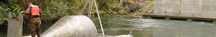
Meridian biologists develop and implement
studies to assess aquatic species composition,
distribution, abundance, productivity and
limiting factors in rivers, reservoirs and
small streams throughout the Pacific
Northwest. We regularly employ field methods
such as screw trapping, weir trapping,
seining, radio telemetry, PIT tag
interrogation systems, snorkeling, boat and
backpack electrofishing, redd surveys,
gill-netting, hydroacoustics, underwater
videography, and benthic and neuston sampling.
We are highly skilled in the installation and
operation of screw traps and work with clients
to determine the appropriate trapping and
tagging systems to meet project goals.
Meridian biologists also conduct habitat
assessments and instream flow studies.
»View Aquatic
Resources Projects
Fish Passage Assessments
Our biologists design and implement studies to assess fish passage feasibility, fish passage injury and survival, and fish entrainment at dams and diversions using mark-recapture methods, fish traps, PIT tag interrogation systems, underwater videography, motion detection software, radio telemetry, and hydroacoustics.»View Fish Passage Assessment Projects
Marine Resources
Following state and federal survey guidelines, Meridian biologists evaluate the effects of bank stabilization, dock construction, pile removal/replacement, and dredging projects on the nearshore environment and recommend measures to avoid adverse effects on submerged aquatic vegetation, invertebrates, forage fish, and other essential marine resources. Meridian staff are trained in the Army Corps of Engineers Eelgrass Delineation methodology.»View Marine Resources Projects
Water Quality / Quantity Assessments and Monitoring
For instream work or continuing water resource project operations, Meridian designs water quality studies and monitors compliance with state standards, documenting these for Clean Water Act Certification. Our work includes multi-year water sampling programs on streams and reservoirs in the Pacific Northwest to assess effects of changing flow regimes on aquatic species and state-regulated parameters. We have analyzed the effects of changing water management protocols on tribal reservations and helped tribes prepare water quality regulations consistent with the Clean Water Act.»View Water Quality / Quantity Projects
Endangered Species Act (ESA) Compliance
Meridian conducts aquatic and terrestrial species surveys, prepares Biological Assessments/Evaluations and negotiates with the NMFS and USFWS to meet formal and informal ESA Section 7 and Section10 requirements on behalf of our clients. We prepare programmatic BAs for multi-phased and multi-year projects and region-wide planning as well as localized species-specific plans. We are familiar with and apply streamlined ESA agreements developed between regulating agencies for certain types of projects in the west.»View Endangered Species Act (ESA) Compliance Projects
Regulatory Compliance, Permitting and NEPA
Guiding clients through environmental and regulatory requirements is one of Meridian's major service areas. We specialize in instream, near-stream, and land use permitting at federal, state and local levels for habitat restoration programs, communication towers, dam construction/removal, fish passage, recreation developments, hatcheries, irrigation projects and utilities and roads. Land use development on federal lands is an area of our regulatory expertise and we have managed NEPA compliance for many actions across the west. We have successfully guided private, tribal, and utility clients through NEPA, from public scoping to final EA/EIS preparation and publication.»View Regulatory Compliance, Permitting and NEPA Projects
Feasibility Studies
Meridian supports project developers and engineering teams conducting siting investigations for new communication, aquaculture, fish collection, pumped storage and traditional hydropower facilities. Our role includes recommending sites, determining environmental, land use, and regulatory constraints of potential locations, and identifying the risks, costs, and opportunities associated with specific sites. Such information is used by developers and engineers to assess project fatal flaws, select sites most suitable for development, and evaluate potential regulatory challenges. Our specific expertise is siting developments on public land due to our extensive experience with management plans for state and federal agencies.»View Feasibility Studies Projects
Terrestrial Resources
Meridian's terrestrial ecologists evaluate upland, riparian and wetland habitat, develop forest management prescriptions, and do large-scale covertype mapping. Our habitat evaluations assess conditions for terrestrial, amphibian, and avian species, and identify mitigation and monitoring plans for project development or operation. We conduct invasive species surveys, develop management plans to assess the risk of spread, and identify methods to control or contain invasive populations. Meridian's forest ecologist prepares silviculture treatments to improve forest stand conditions to address habitat objectives for a diversity of species, or to focus on providing habitat for a few select species.»View Terrestrial Resources Projects
Wetland Resources
Meridian inventories and delineates wetlands, evaluates their functions and values, and prepares mitigation and restoration plans. Our specialists navigate city and county critical area ordinance compliance as well as the state and federal permitting processes needed to implement development and restoration actions.»View Wetland Resources Projects
Hydropower Licensing, Relicensing and Compliance
Meridian guides clients through FERC's rigorous regulatory and compliance requirements. As members of FERC's Engineering and Environmental Services contractor team since 1998, we conduct technical analysis and NEPA compliance for projects nationwide, including reviewing license applications for adequacy, writing FERC's EAs, and preparing license articles. For our utility and private hydropower clients, we prepare environmental feasibility analyses and licensing documents, provide strategic planning, and conduct natural resource studies. License compliance is a major service area of Meridian's, targeting fisheries, fish passage, water quality, terrestrial resources, and recreation.»View Hydropower Licensing, Relicensing and Compliance Projects
Writing, Editing, and Document Production
Many clients retain Meridian for this service area because of our expertise in writing clear and concise technical reports and environmental compliance documents. Meridian staff have provided report editing, GIS map production, and document production services for two congressionally appointed fisheries panels, resulting in over 350 reports. We ensure that written materials convey the intended concepts clearly, concisely and logically for the target audiences.»View Writing, Editing and Document Production Projects
GIS, Aerial Mapping, Data Management and Analysis
A core function of Meridian's work includes the management and analysis of technical data. We are able to manage both large and small data sets using tools appropriate for the required analysis. The dominant tools used by our staff include Excel, Access, and ArcGIS geospatial analysis. We commonly work with large streamflow, water quality, and geospatial data sets and have developed templates to quickly analyze the data and summarize, graph, or map the results. Meridian maintains in-house libraries of GIS data from State and Federal agencies for geographic areas throughout the Pacific Northwest; this information is available to all of Meridian's staff and clients. Meridian also offers drone services, including aerial photos, video, high-resolution maps, and 3D models.»View GIS, Aerial Mapping, Data Management and Analysis Projects